
“How Is It Out There?” – The Emotional Roller Coaster of the PCT

Here’s our story from over 200 miles of Southern to Central Oregon on the Pacific Crest Trail. We’ve noticed recently that people keep asking us “How is it out there?”
How is it out there?
Chuckle.
Read on…

It was the 4th of July when we reached the California / Oregon state line and were welcomed by Pinnacle. Pinnacle, hiker and author of Oregon Backroads Guide to the Pacific Crest Trail, had an Independence Day picnic all set up just waiting for hungry hikers to pass through. Hotdogs, watermelon, chips, and beers were just what we needed to celebrate the holiday. Thanks for the warm welcome, Pinnacle!!
Once passed the state line, we noticed almost instantly why some hikers refer to Oregon as the “moving sidewalk.” For nearly 500 miles, the PCT is truly gentle to its hikers and is full of incredible sites along the way. Our first major Oregon landmark we were anticipating was Crater Lake 130 miles north. We were expecting a resupply package at the national park and decided to make a lofty goal of reaching Crater Lake within five days despite the fact that it had been 2 weeks and over 350 miles since our last zero.
Well, on we went for the next few days walking practically every minute of daylight. We were pretty proud ourselves for our back to back 30+ mile days and were confident we could reach Crater Lake by Saturday to snag our resupply package.

It was about 9 pm when we ended a 34 mile day still leaving 35 more to the park. We camped near a spring that had a serious mosquito infestation with several other campers. It seemed we woke 2 older men when we arrived to the campsite, but they didn’t seem too upset. The conversation quickly turned to tomorrow’s forecast of all day rain. Joy.
Now, we haven’t seen much rain on the PCT. And by not much, I mean we have dealt with walking in the rain twice this entire trail, both of which were in Southern California. I can already hear the AT hikers telling me to suck it up, but, ugh… walking in the rain is something I just don’t get used to.
Well, morning came and we were awoken by rain pitter-pattering on our tent. We waited a little longer than usual to start packing up, hoping for a break in the weather that didn’t come. Time to get this wet show on the road.
On we walked through the clouds and the cold drizzle. We guessed the temperature was around 45 degrees, and we weren’t interested in stopping for anything – not food, not water, nothing. We just kept walking all day, hoping and pleading with the clouds to break. I tried to entertain my mind with any thought other than how cold I was and how badly I just wanted to stop and crawl back into my dry clothes and warm sleeping bag. I started listing things I was thankful for – it’s only drizzling and not a down pour, it’s not that windy, the rain is creating an incredible forest fragrance…
I felt my frustration weighing me down as we continued to climb a thin ridgeline up and up. Ugh, I didn’t want to go up. I didn’t want it to get any colder or be exposed to the wind on top of the mountain. Why are we still going up?
I checked our guide on my phone, a joyous activity when you are using wet fingers on a wet screen. We still had several hundred feet to climb up Devil’s Peak. Sigh. It was about 1:00, and we stood in the rain to eat granola bars and drink some water. So far, we had traveled about 12 wet miles without stopping to eat or drink. Yeah, probably not the smartest, but when the word “hypothermia” continues to cross your mind, your priorities somewhat shift.
On we trudged up the mountain, trying to keep our patience. I was thrilled when I saw the trail winding towards a pass between two peaks, knowing we would begin our descent to slightly warmer temperatures. But my heart sank and I stopped in my tracks when the trail turned the corner as it wound to the other side and I saw that it was buried under snow. Slippery, cold, wet snow. Siggghhhh.
Sean led the way and I followed his big footprints. Thankfully, other hikers ahead of us had created a trail in the snow making the navigation much simpler. It was a slow go, but the snow section was, gratefully, short. I was relieved to see a dirt trail resume, and we continued down the mountain.
The drizzle and gloom continued, but on we walked through the afternoon. It came to our attention that we had each only drank about a half liter of water all day so we stopped to correct that. It was also then that we realized we had already passed the most convenient water sources leaving only one between where we were and the park that was still about 15 miles away. From this point, it was another 3 miles to the spring and an additional half mile down a side trail. Well, one more hour of walking anyway.
We arrived at the side trail for Jack Spring and noticed the abundant camping spots at the intersection. We also saw a note at the intersection stating the spring was still flowing. Well, that’s positive.
We left for Jack Spring from the PCT around 5:00. A half mile for us is typically a 10 minute walk on the dot. But, of course, not this time. Not this time when we were wet, cold, frustrated, dehydrated, and hungry. This time the side trail seemingly disappeared when the PCT was out of site. My guide GPS had the spring itself marked, but the trail to the spring was a mystery covered with fallen trees and branches. We tried and failed miserably to locate this damn spring while my GPS kept bouncing us around. We climbed limb after limb, bushwacking our way to some unknown dot on the screen of my phone. The irony of searching for water while it was raining really weighed on my spirits.
5:30 came and went.
5:50.
6:00. I couldn’t fathom why we hadn’t found it. What little was left of our patience was expiring. We were exhausted. I could feel tears welling up in my throat, but I choked them down. The mountain doesn’t care if you cry. The rain will continue, the blowdowns still need navigated, you most certainly still need water.
6:10. The blue GPS dot of us was nearing the pinned point on the map at a sloth’s pace.
6:20. Ok, I’m just about on it.
6:23. “It says I’m on it.” Our eyes were scanning the gloomy forest and our ears strained to hear trickling water beyond the rain drops.
6:27. Where the actual f*@k is this spring!!??!
6:30 An HOUR AND A HALF after breaking from the PCT, we locate Jack f’ing Spring. I hate you, Jack.
At about 6:50, we got back to the campsite and began the chores. Thank the heavens getting back to the PCT proved far easier. By then, we were both starving, but – WOULDN’T YOU KNOW IT – the rain decided to pick up. I started heating some water in an attempt to make mac n cheese while the rain fell down on me. When the shivering started, it just didn’t stop. Sean did his best to pop the tent and keep the inside dry. Suddenly, I recalled having 4 oatmeal packages and an instant mashed potato. No backpacker food is worth hypothermia.
I handed Sean the instant dinner and made my way into the tent for the night. It was then an obstacle course of keeping the wet things separate from the dry things, escaping the damp tent floor on our NeoAir rafts, and hoping the rainfly does its job. But, at last, we were finally back in our tent – our haven – mostly dry and warm. I looked at my soppy wet hiking clothes knowing I would be putting them on the following morning. Sigh.
Morning came and the cold wet clothes were just as awesome as you’d expect. We were now 12 miles away from Crater Lake and nothing was slowing us down. We checked for cell service a few times in an attempt to connect with a friend that lives in the area. She knew we were coming through, but no concrete plans had been made. I thankfully got a signal and let Missy know an approximate arrival time to the park having no idea what her schedule was.
We, seriously, booked those 12 miles in slightly under 4 hours without considering stopping. We were just about to the highway, when suddenly Sean turned to his right, clearly excited. Our friend, Missy, had surprised us with big hugs, food, beer, and a whole day to spend with us. It felt like a dream, and most certainly was a miracle.
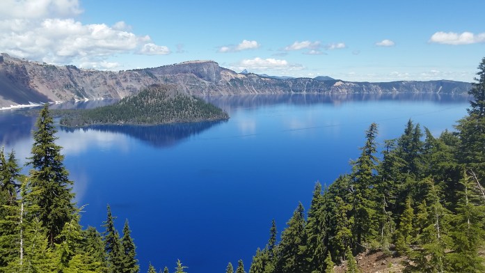
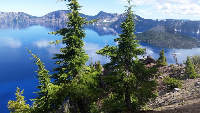
After our much needed rest and recuperation with our dear friend, we returned to the trail once more. I was thrilled to have perfect weather as we entered Crater Lake National Park. And, truly, this is one of the most beautiful places I’ve been lucky enough to visit. I swear, you’ve never seen the color blue until you’ve seen Crater Lake.
It wasn’t too many miles after the park, however, that Sean began noticing pain from his right shin. As the days and miles went by, the pain continued to grow. It became clear quickly that he needed to get off trail, but when you’re in the middle of the woods, you still have to tough it out to an exit point.

We checked our guide and learned that he would have to hike about 35 miles to get to the nearest highway. And that highway could get us to Bend. And from Bend we could make it to Phish??
A few of our very close friends were currently traveling across the country to see two nights of Phish at the Gorge Amphitheater, one of the most beautiful and unique venues in the world. Well, we needed to get off the trail anyway, so why not go on a hitchhiking adventure to the show?
The next two days were somewhat of a struggle as Sean battled the pain in his leg using ibuprofen and snow stuffed in his sock as treatment. But, we excitedly got to Highway 58, and stuck out our thumbs to the many passing cars. We were right in the heart of the Deschutes National Forest being eyeballed by curious families in trucks, SUVs, and RVs with all of their outdoor rec toys in tow.
It took an hour and a half, but suddenly a lady in an SUV pulled over for us. Trish was heading to Bend and had just commented to herself that she was bored and wished she could pick up some hitchhikers or something…
Step 1 – made it to Bend!! Trish took us to a cheap motel with nearby restaurants, grocery stores, and even a thrift store. We instantly took to the internet searching Craigslist, Facebook, and Phish forums looking for our 6 hour ride to The Gorge. We sent some emails and posted our story, but we went to bed without a plan for the next day.
About 9 am Friday morning, we got a response. We explained our story to Davin whose friend had bailed on accompanying him. And just like that, we had a ride and even scored a good deal on tickets via Craigslist. At 11:30, we began the 6 hour ride which would get us there just before the show started at 7. MAGIC!!!
The next two days were full of fun, connecting with our recently engaged best friends, and enjoying a truly incredible space – not to mention lots of groovy tunes and smiles for miles and miles and miles…


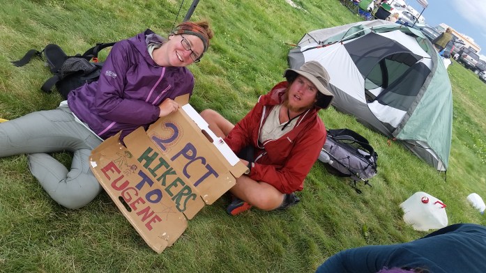
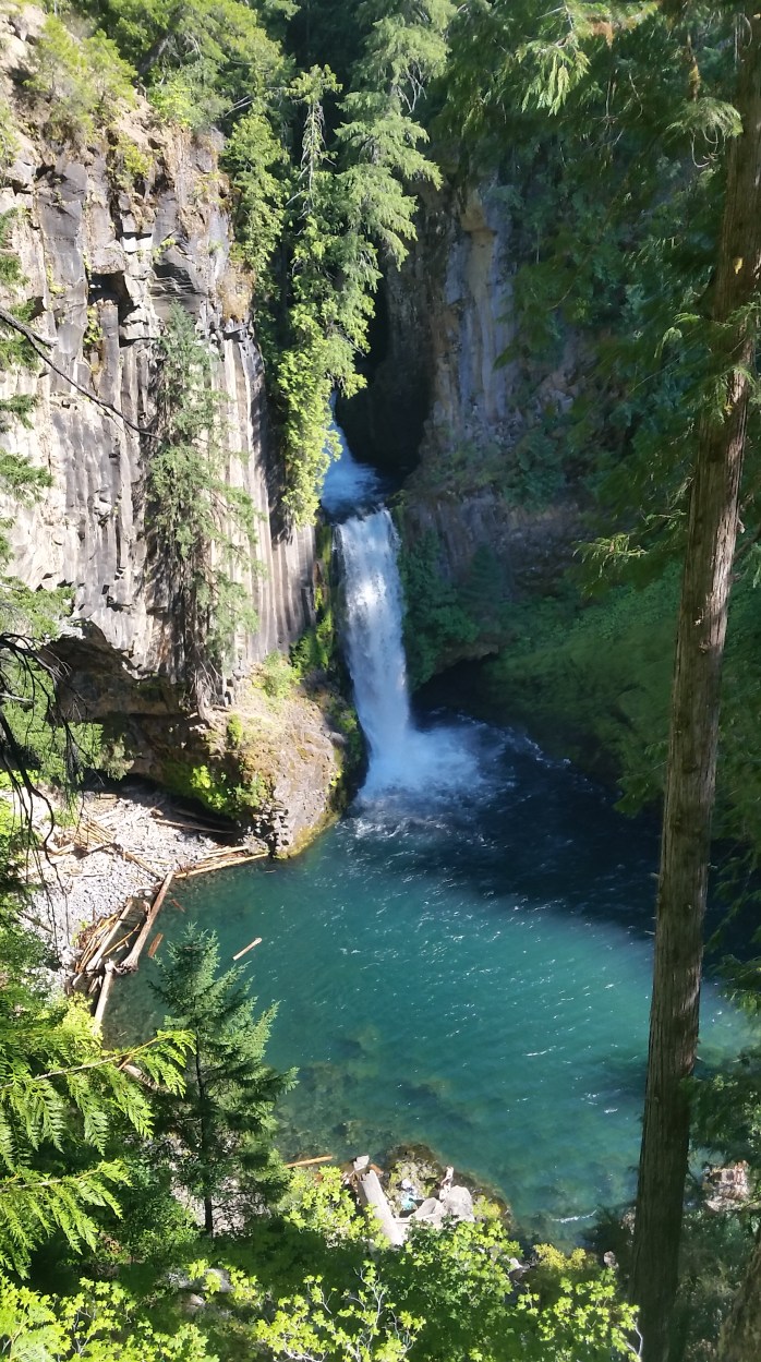
After the blissful weekend, we easily caught a ride to Eugene where it was slightly more convenient to get back to the trail. We checked into a motel and very unexpectedly decided to take 4 additional zero days and let Sean’s leg heal. Our friend, Pat, was in the Eugene area and returned us to the PCT after exploring Umpqua Hot Springs, several waterfalls, and dinner and breakfast on the lake.
It had been a week since we had stood in that same spot with outstretched thumbs. Our much needed rest and recharge was over, and it was time to get back to the task in front of us. What a way to celebrate being halfway done with the PCT!
So… how is it out there?
It’s unbelievably beautiful, buggy, spontaneous, hot, rainy, frustrating, painful, magical, difficult, blissful, smelly, soul crushing, inspiring, long, wet, cold, interesting, hellish, unpredictable, boring, slippery, dusty, breathtaking, snowy, muddy, tough, sunny, repetitive, windy, dirty. It’s all that and so much more, simultaneously, and can bring you the highest highs and crushing lows. That’s how it is out there. Yet somehow, we manage to keep walking.

Absolutely love it!
Pingback: Appalachian Trail vs Pacific Crest Trail – Infinite Geography
I hated getting back from my thru hike and trying to answer, ‘how was it?’ or worse ‘was it fun?’
Seriously, such a loaded question!! Congrats on your thru 😊