
Wowed by Washington

We were far too comfortable in our hotel room at Snoqualmie Pass to check out. We had completed nearly 250 miles in the 11 days we had been in Washington and had another 250 to complete to touch the Canadian border. Although we were doing our best to make good time, the lure of the hotel room proved too strong. We flipped a coin and tails won – zero day it is!
And after lots of food, beers, and hours of tv, the zero day was over before we knew it. At about noon the following day, we were back to it. Initially it’s always difficult to pull yourself away from the comforts of town, but as soon as we were back on a ridge line with incredible views, we felt like we were exactly where we belonged.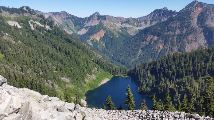

We had three days of food with us that would get us to the tiny town of Skykomish where a mail drop awaited. We kept our average around 25 miles / day climbing up and down mountains, passing waterfalls, and eating handfuls of ripe huckleberries.

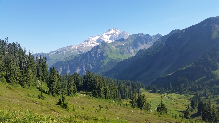
Mt. Rainier continued to shrink behind us as we moved north and another prominent mountain came into view. We stared in awe of the giant peak when, suddenly, the sound of falling rocks filled the air. Seemingly out of nowhere, football sized rocks came tumbling down the mountain above us, bounced on the trail just feet in front of Sean, and continued down the mountain. Thankfully, it was only a half dozen rocks, but it left us a little shocked. We continued walking with “what ifs” floating inside our heads.
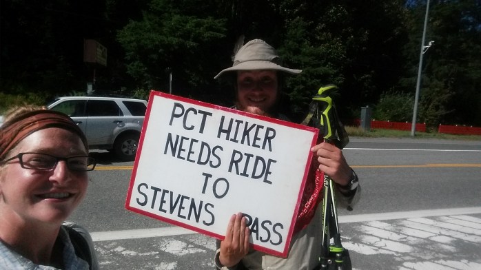
On a Thursday morning, we arrived at Steven’s Pass and walked straight through the ski resort. We came to Highway 2 and stuck out our thumbs to get a ride to nearby Skykomish. A family quickly picked us up and drove us into town where breakfast awaited.
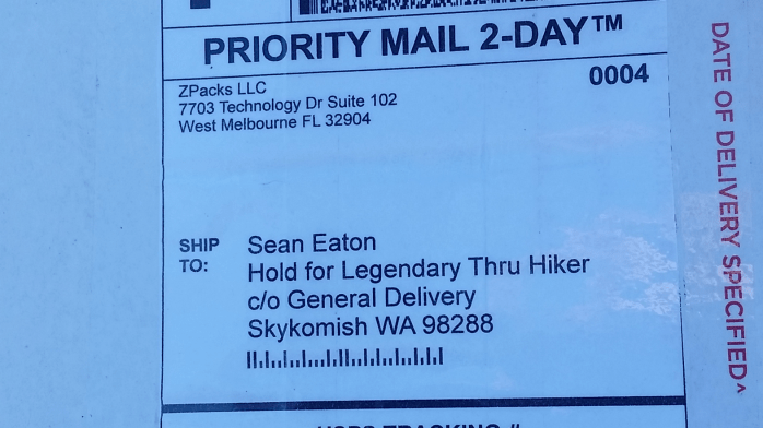
After eating, we walked to the post office to retrieve our packages. This mail drop would get us to our final stop in Mazama just 60 miles from the Canadian border. Also awaiting us at the post office were two tent pole segments for our Big Agnes Copper Spur to replace our cracked ones as well as a brand new pack from ZPacks. Sean’s Arc Blast frame wasn’t exactly arcing anymore, and ZPacks immediately offered to send a replacement pack. Thank you Big Agnes and ZPacks for the amazing customer service!!

After about 6 hours of binging on food and the internet, we headed back to Steven’s Pass and continued north on the PCT. We noticed some haze on the horizon, but thankfully, there was no news of nearby wildfires. Last year, many thru-hikers were unable to hike a majority of Washington due to fires. So far, we were in the clear and very grateful.
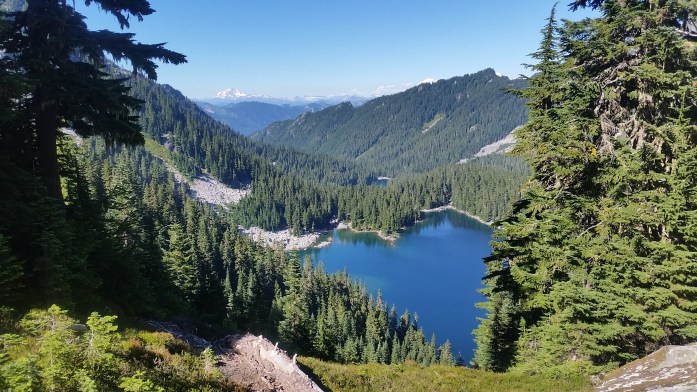
As we walked, the prominent mountain we had been noticing grew larger and larger. We finally learned the mountain’s name as we entered Glacier Peak Wilderness on a beautiful Saturday morning. Towering above 10,000 ft, Glacier Peak is the most remote of the 5 Washington volcanoes and also has more active glaciers than any other place in the lower 48. The PCT traverses 60 beautiful miles through the wilderness area boasting stunning views of the mountain and the countless craggy peaks that surround it. We ended our Saturday at Mica Lake, a crystal clear glacial lake and our favorite campsite yet, and awoke to a breathtaking sunrise the next morning.


By late Tuesday afternoon, we had completed the stretch through Glacier Peak Wilderness, entered North Cascades National Park, and arrived at Rainy Pass on Highway 20. Within a half hour, we were picked up by a couple of young travelers much like ourselves and headed into nearby Mazama to get our resupply package for our final stretch in Washington.

We indulged on food and beers from the general store in the tiny town and decided to check out the nearby hiker haven hosted by Ravensong, the first female to ever thruhike the PCT. Unfortunately, she wasn’t there that evening, but another host was, and the bunk house was still open.
We returned to Rainy Pass the following morning and were now only 60 trail miles from the U.S. / Canadian border. Since we decided not to go into Manning Park in Canada, we had an additional 30 miles to hike southbound after reaching the monument to return to Hart’s Pass Campground. Here, we would hope to catch a ride back to society.
From Rainy Pass, we hiked nearly 25 miles despite our late morning start. Our day ended climbing switchback after switchback into the sunset, and we slept happily on top of a mountain.
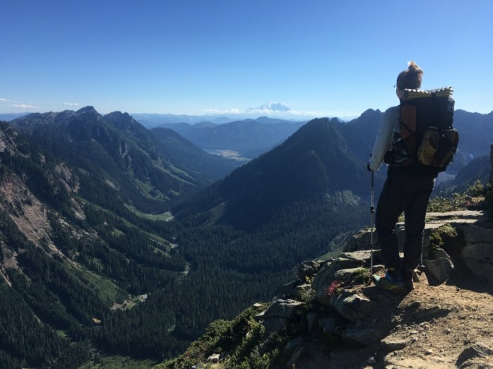
We came and went from Hart’s Pass the following morning knowing the next 30 miles would be walked both northbound and southbound. In some ways, I lamented that this wasn’t the end of our journey. Truly, Washington was a symphony and here we were in the grand finale marching towards the finish line. I continued to remind myself that this wasn’t, however, our finish line – that in about a week we would be standing in Southern California on Highway 58 between Tehachapi and Mojave. That we had 140 miles of bone dry desert from there until Kennedy Meadows. And from KM, an additional 450 miles through the High Sierra in King’s Canyon, Sequoia, and Yosemite National Parks, around Lake Tahoe, and finally back to I-80. As I walked through the North Cascades, it was truly equal parts dread for the desert and excitement for everything else. I wanted to be done, yet I yearned for the Sierra. Those 590 miles had been hanging over my head since the day we decided to skip them. And they most certainly would not go undone.
I walked on taking in the surrounding landscape, appreciating the shade from the tall trees I knew weren’t going to exist in the desert section that awaited me. I sang praises for the incredible weather we had been blessed with for the entire 500 mile stretch in Washington, something I knew we wouldn’t have experienced in a straight northbound hike. I reminisced on our virtually private tour of the PCT as we were consistently ahead of the hiker “bubble.” I remembered how short the section of snow was outside of Truckee. And though we still had nearly 600 miles ahead when we finally reached the border, I couldn’t help but smile and give thanks for this incredible journey.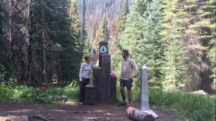

We spent about an hour at the monument taking photos and eating snacks, and for the first time on the PCT, we walked southbound for the 30 miles back to Hart’s Pass. That night, we camped at a site leaving 16 miles for the following day. Our overly used Pocket Rocket stove had been working very slowly due to corrosion, so I asked another hiker if we could borrow theirs to cook. They were happy to help us out. After returning their stove, another man approached, told us he was finishing the Washington section tomorrow, and gave us his barely used Snow Peak stove. We were stunned. Thanks for the trail magic, sir, and congratulations on finishing your section!!
Our final day of hiking in Washington arrived, and we set out for the 16 miles to Hart’s Pass. The sky looked like rain, but never opened up on us. Since we entered Washington on August 3, we had only seen two days of light drizzle with the only weather disappointment being socked in on Goat’s Rocks. Otherwise, it was nothing but sunshine and blue sky. We made it back to Hart’s Pass totally dry despite the ominous clouds.
It took about 15 minutes for us to get picked up. Alan was enjoying a long weekend in the National Park and was heading back to his home in Bellingham. We asked for a ride to nearby Mazama where we intended to hitch a ride to Mount Vernon (where Highway 20 meets the I-5) or all the way to Seattle if we got really lucky. After hearing our story, Alan offered us the ride to Mount Vernon. Not only were we grateful to have found a ride so quickly, Alan was incredibly kind and very knowledgeable about the area. In fact, we had once again found ourselves in the company of very accomplished athlete. Specifically, Alan was a former guide on Denali (North America’s tallest mountain) and had guided trips on Aconcagua (South America’s tallest mountain) and Kilimanjaro (Africa’s tallest mountain). During the three hour drive, Alan pointed out some of his favorite hiking spots in the area and shared his climbing stories from the Pacific Northwest and beyond. Thanks for your help, Alan!! It was such a pleasure meeting you!
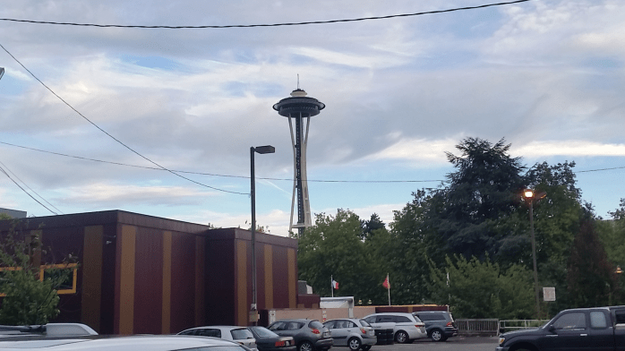
Alan dropped us off at the Mount Vernon Amtrak station, and we were thrilled to spot a brewery right next door. We walked over and ordered beers and huge plates of barbeque while researching our options to get back to southern California. We booked a train to Seattle that left within two hours and two nights in a Seattle hotel.

We left the brewery with smiling, rosy cheeks and full bellies and waited on the platform at the closed station for our 8:07 train. We weren’t surprised when the train was running late, it is Amtrak after all. But when a northbound train pulled up to the tracks at 8:40, we started asking questions. Another would-be passenger told us there were coal protesters blocking the tracks just south of Bellingham blocking both our southbound train and the northbound train sitting at the station. Well, at least there’s a brewery nearby. We walked back over and ordered another beer while we waited. We were fighting exhaustion, but had no real options but to wait and dream about the empty hotel room in Seattle. The friendly bartenders let us sit at the bar after closing, and we returned to the platform at 10:30. The northbound train was still right were we’d left it. I called Amtrak, and they gave me an 11:00 ETA explaining that the protesters had built some sort of structure over the tracks which had to be removed by crane. I correctly assumed the ETA wasn’t going to happen. I called again at 11:15, 11:50, and 12:30 each time getting a new ETA that didn’t come through. I was told that Amtrak was looking for buses to pick us up, but to no avail. I set up my sleeping bag on a bench, and Sean blew up his Thermarest on the platform. Many passengers had exited the northbound train by this point with family or friends picking them up, but we didn’t have that option. Eventually, I opened my eyes enough to see the northbound train start to move southbound. Huh? Then, a freight train came into view moving northbound. I made another call, got yet another ETA, and fell back asleep. At 4 am, I heard the horn of another train and wouldn’t you know, train 517 heading southbound to Seattle was approaching the platform. We both sleepily began packing up our bags, but noticed the train wasn’t slowing down. I panicked and ran to the side of the tracks waving my arms like a crazy person. I was totally shocked to see the train come to a stop just before it was passed the platform.
“I can’t believe you’re still here” the conductor said.
“We had nowhere else to go!”
So at just after 4, we boarded our 8:07, two hour train to Seattle. We arrived at our hotel just before 7 am completely exhausted.
From Seattle we started researching our options to get back to Bakersfield, CA where local transit would get us back to the PCT. All along, we were intending on taking the Amtrak from Seattle to Bakersfield, but…yeah, fuck that. That route included an Amtrak to Sacramento, switching to a bus, then switching to another train for $125 each and a total of 30 hours of traveling IF everything was on time. I interneted my options and found a 4 hour flight from Seattle to LA for $110 each and a 24 hour rental car to be returned in Bakersfield for $60 with a total of about 7 hours of travel depending on LA traffic. Well, that decision was a no brainer.
After a zero day in Seattle, we boarded our plane and found ourselves stuck in insane traffic outside LA. Big surprise, I know. Our two hour drive became a four hour drive, but we were thrilled when our day of traveling came to an end in Bakersfield.
And here we are. Enjoying the last bits of air conditioning before we begin our final 600 miles through desert heat and then, finally, through the High Sierra. By the end of next month, we’ll have completed the entire Pacific Crest Trail.

Great post, loving the pictures. So inspiring, my goal is Campo on May 1 next year.
Thanks, ed! Good luck on your hike next year. We are so in love with the PCT.
Pingback: It Wasn’t a Thruhike – Thoughts from Completing the Pacific Crest Trail – Infinite Geography
Pingback: Appalachian Trail vs Pacific Crest Trail – Infinite Geography