
Western Wildlands Route Segment 6 – Kanab, UT to Soldier Summit, UT

We are riding the Western Wildlands Route (WWR) on bicycles northbound and started at the AZ / Mexican border about 3 weeks ago. Since we are tackling the route northbound, “Segment 6” is our fourth segment.
Click to read Segment 7, Segment 8, and Segment 9.

Day 22 – 80.5 Miles / +5900 ft
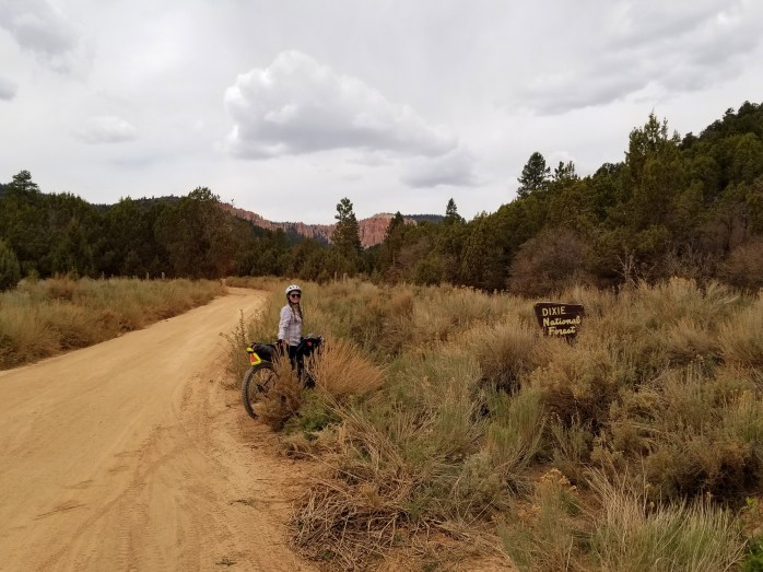
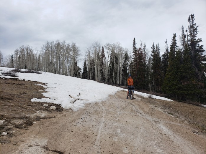
We left the care of Lynn and Richard in Kanab and headed back out on the WWR after our highway reroute through the Navajo Nation. We were elated to return to the backroads with big views and a lot less stress of worrying about cars. We had just entered Utah, and the scenery seemed to know we were in a different state. Just north of Kanab we cruised through a section of Grand Staircase Escalante featuring towering flat top monoliths. Our day was mostly spent climbing from around 5,000 ft to nearly 8,000 ft. on forest service roads.
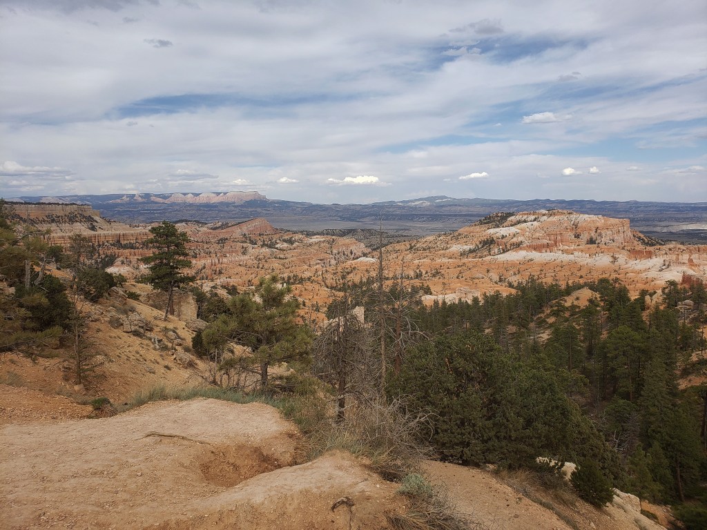
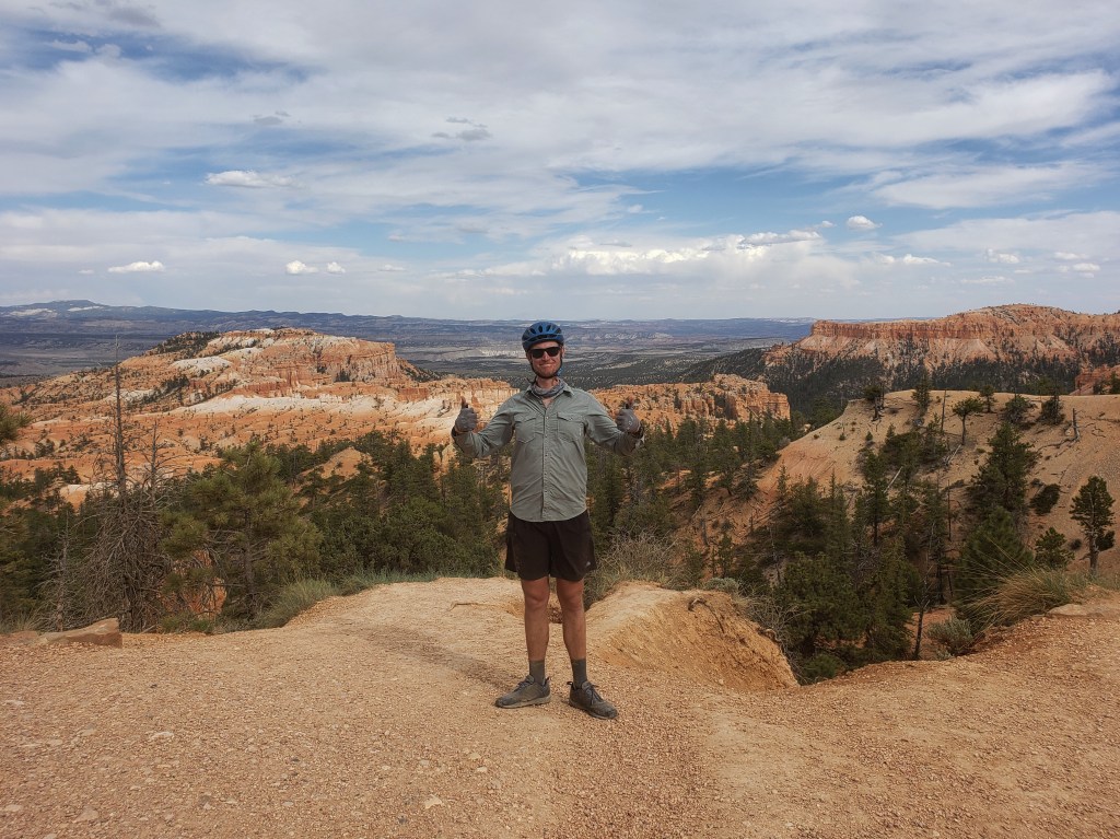
Around 6:00, we headed into Bryce Canyon National Park for a quick view and resupply. The route had us enter the park though an unofficial entrance which led to an encounter with an unhappy park ranger. I did my best to explain the route, that we would pay, and that perhaps the designers of this route and the park should communicate. She promptly “reported us” to the gate keepers and deeply annoyed me. We checked out the view, got a quick resupply, and paid the $35 park entrance fee for the 25 minutes we spent there. We headed north from the park and reentered national forest land where we found a campsite for the night.

Day 23 – 80.4 Miles / +5300 ft
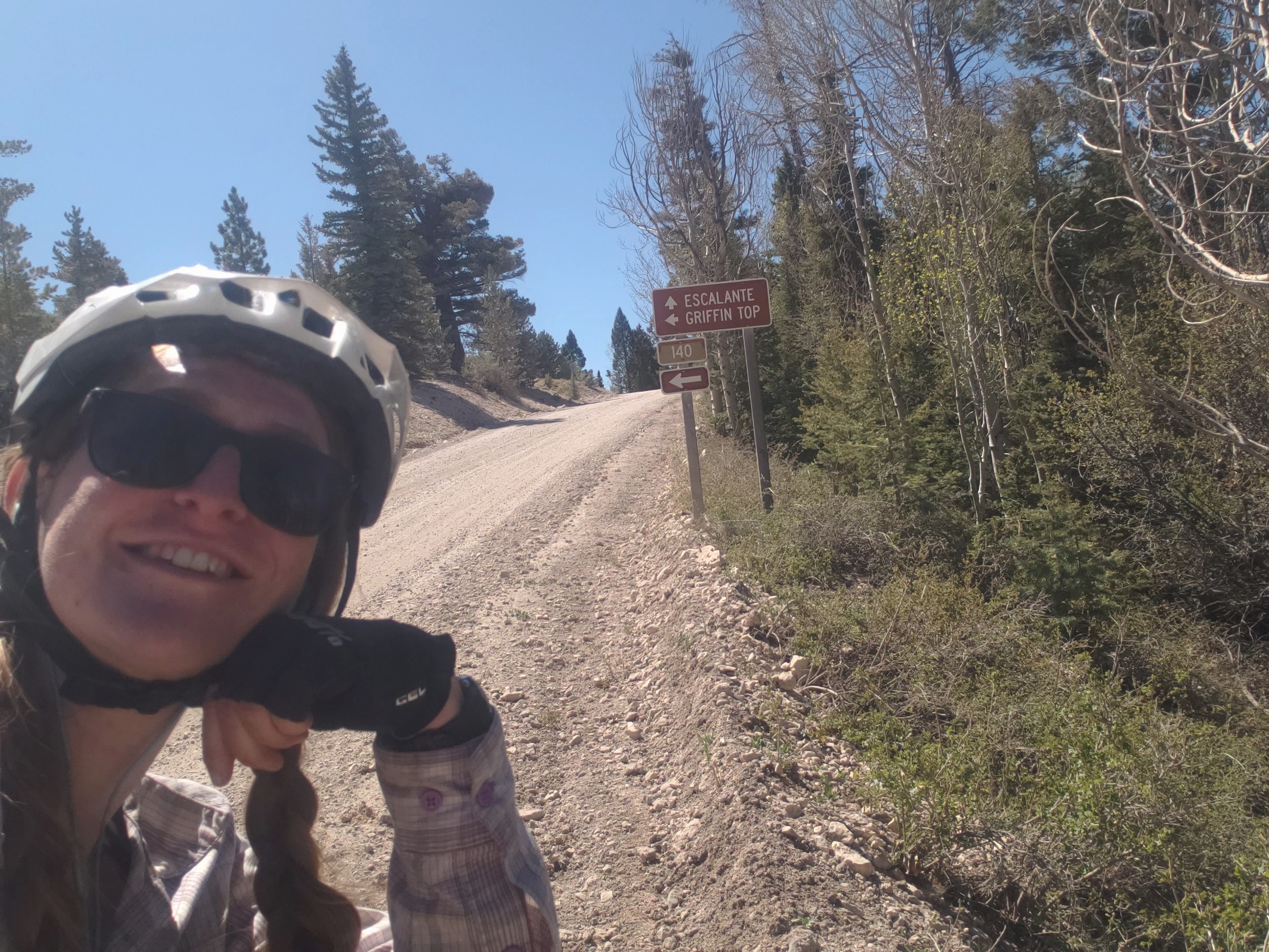
We woke early and realized for the first time of the trip that we were cold, but it didn’t take too long to warm up as we rode. Our whole morning and early afternoon was spent climbing Griffin Top up a dirt road from 7000 ft to 10500 ft. By late afternoon, we started a long, fun descent to the tiny town of Loa back down to 7000 ft. The 20 mile downhill ride was dreamy as we glided through open meadows with stunning views of towering canyon walls in the distance. We could feel the wind starting to pick up as we headed into Loa with occasional gusts pushing our bikes across the dirt road. In town, we resupplied at the small general store, hopeful that maybe we’d find a cheap hotel room to get out of the wind. Unfortunately, that was just a dream, and we rode out of town looking for the nearest suitable spot to pop up our tent. As we were riding out of town, a dog started chasing us from a house that had a small cattle operation in their back yard. We did our best to shoo it away, but it was pretty set on following us. A mile down the road, we turned onto the highway, and the dog continued to follow us. We rode on the shoulder, the dog following us and chasing cars in either direction with a couple very close calls. I shuddered at the thought of being somewhat responsible if the dog were to get hit. A couple miles later, we found a spot, ate dinner, and pitched our tent as the wind howled. We spent an unrestful night listening to the wind attempting to fold our tent and seeing the little dog use our tent to try and block the wind.


Day 24 – 54 Miles / +2500 ft
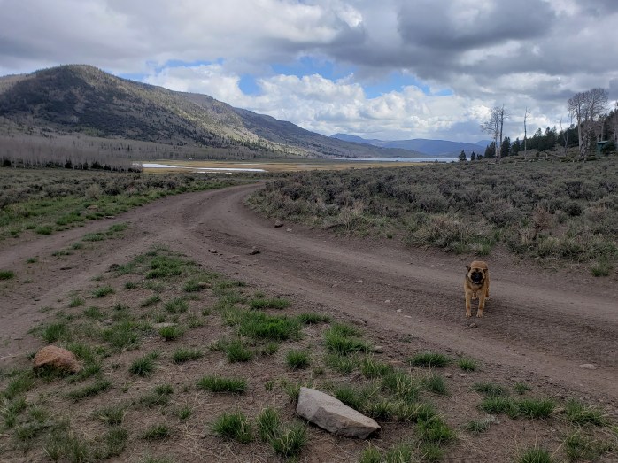
In the morning, big gray clouds filled the sky, the wind remained intermittent, and the little dog was still roaming around our tent. We packed up the bikes, and as if on cue, the little dog began running by our bikes when we took off. We returned to the highway for a couple miles while the dumb dumb little dog chased cars and wandered in the middle of the road. As we hit the dirt, I found a number for a semi-local animal shelter to see if they had any advice. I explained the situation to the lovely volunteer, but she didn’t really have any solutions. She told us the dog was a cattle dog, may or may not be claimed and regularly fed, and thanked us for trying to help it. Basically, she said don’t feed it and don’t worry about it. Once we were off pavement, I was able to relax a little more and enjoy the ride. The next 15 miles we spent riding dirt roads to Fish Lake while the little dog (who I named Gerry) trotted along keeping an impressive pace.
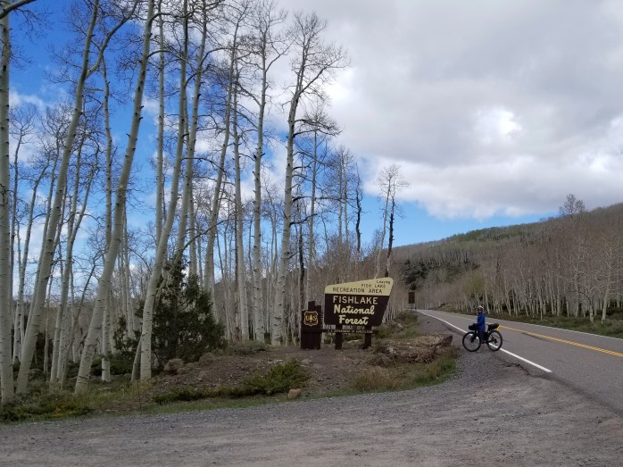
When we arrived at Fish Lake, a couple was out photographing the beautiful aspen grove we were riding through. We said our hellos, and the gentleman informed us we were standing in Pando, the world’s largest known living organism. Pando is an aspen clone consisting of over 40,000 individual trees covering 106 acres. We had heard of the grove, but we didn’t know we would be riding to it. It was quite a lovely surprise. The couple noticed Gerry, and we explained the situation. Thankfully, they were willing to hold onto the dog while we pedaled away on pavement for fear the dog would once again try to start a fight with traffic.
From Fish Lake, most of the rest of the ride to Salina was downhill. We followed the WWR through a canyon following Little Lost Creek. The sun overpowered the cloud cover as we headed toward town. We came out of the canyon returning to big wind gusts, crossed Interstate 80, and got to Salina. We both immediately agreed to end our day in town to escape the elements and clean up.


Day 25 – 61.3 Miles / +6300 ft
We awoke early knowing we had a big day of climbing ahead of us. Thankfully the wind had died down, but the forecast called for highs in the 60s over the next couple days and lows dipping below freezing. And that was for town at 5,000 ft in elevation. We were heading up to 10,000+ ft.
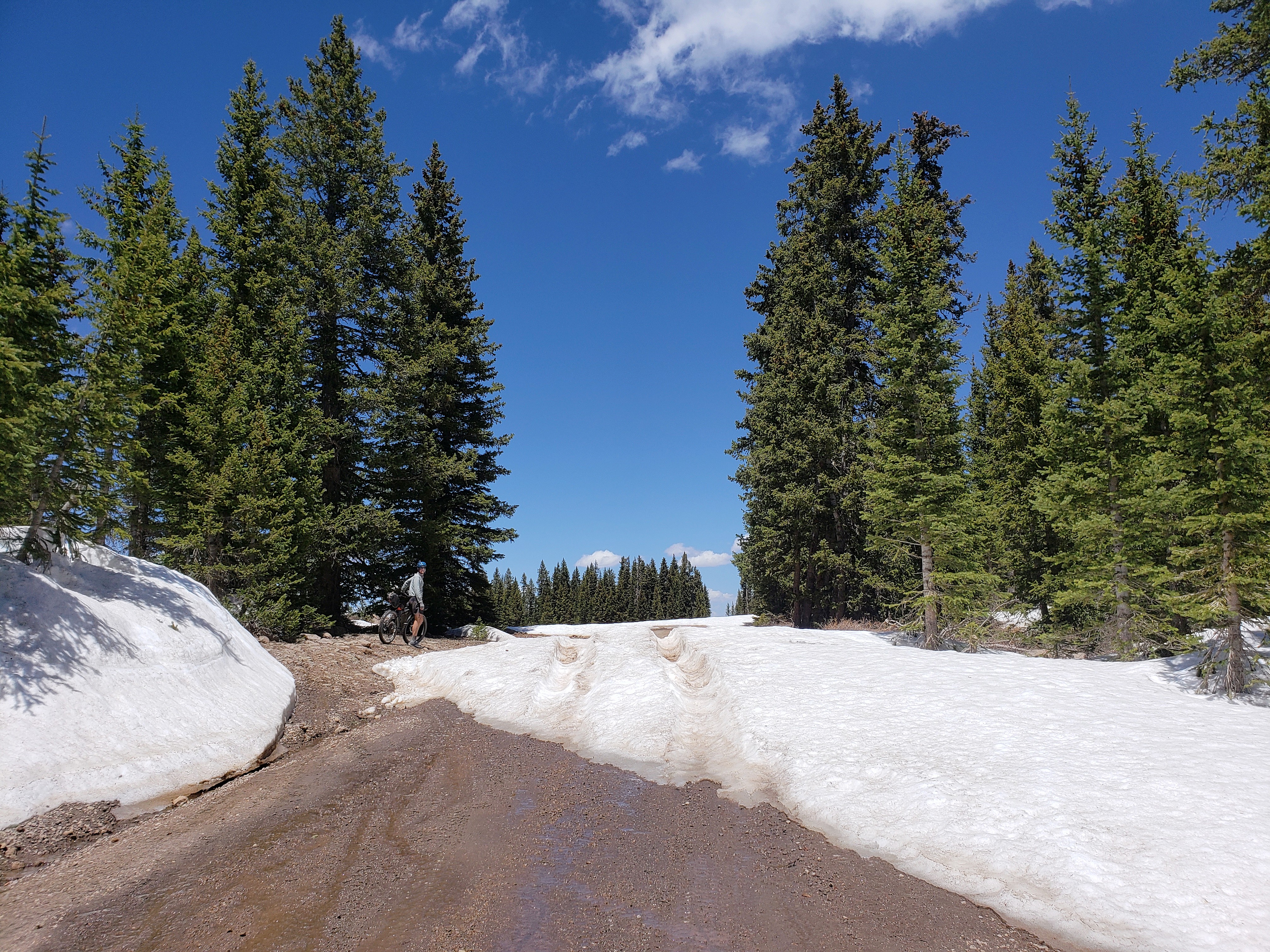
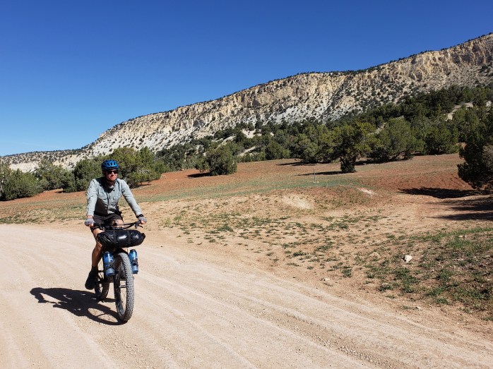
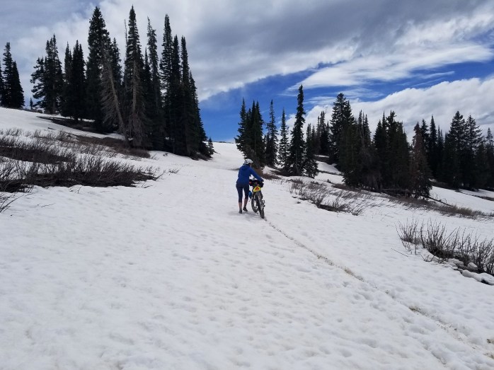
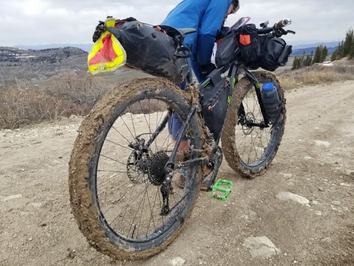
We started the climb just outside of Salina heading up into Fish Lake National Forest on gravel roads under clear sunny skies. The climb was slow and steady with the steepest portion between miles 15 – 20 where we had to push our bikes on occasional short segments. The landscape changed from sage scrub, to pine trees, and then miles of Aspen trees. We took our lunch break around 1, and the sky was almost completely overcast. As soon as we stopped riding, the cold settled in, and we did our best to keep our lunch short and keep moving. Eventually, we got to and above treeline and came to our first patch of snow for the day. We crossed the section and continued up. At this point, the WWR was on a road called Skyline Drive that essentially just rides the ridge for over 50 miles between 9,000 and 10,700 ft. As we continued on, we came to more and more patches of snow. In between the snow, the clear patches were completely saturated, and the clay mud began accumulating on our tires. Mud, gravel, and little sticks started piling up on the tires growing quickly layer after layer. It seemed we were discovering what Utah’s “impassible mud” was all about.
Our next hurdle was a stretch of snow as far as we could see. We were about 500 ft and a mile or so shy of the high point for the day. Beyond that point, however, we wouldn’t come down below 9,000 ft for 50 or so miles. We started questioning what we should do as clouds loomed and snow stretched as far as we could see. We decided to attempt to carry on, literally carrying our bikes over large sections of snow. When we came to uncovered ground, we attempted to ride, but eventually the mud clogged and locked our tires. We were left without much option – we had to turn back.
We carried our bikes back down what we had struggled through feeling defeated. As we exited the snow, we tried unclogging some mud from the wheel enabling them to spin once more. As we gained speed on the downhill, mud and rocks began to fling free and the majority of the debris came off of the bikes. It was a little heartbreaking making the descent, but we knew we were making the right choice. Without knowing what route to take, we retraced our ride downhill back to Salina. What took us 8+ hours to climb took us under 2 hours to descend. We returned to the hotel wet, dirty, and cold to create a new game plan for this segment.


Day 26 – 50.8 Miles / +1500 ft
Overnight, the low in town was about 28 degrees. At 10,000 ft, it probably got down to around 15. We were happy to wake up warm and decided our only option was to ride the highway around Skyline Drive since the WWR simply wasn’t passible yet for bikes. The high for the day was 60, and the sky remained overcast. We watched the mountains and ridgeline to the east completely covered in snow knowing we made the right choice.
We were grateful for the wide shoulder and light traffic as we rode our way north up Highway 89 through the heart of cattle country, ubiquitous to the rural West, and Mormon country, unique to Utah. It became abundantly clear that it was Sunday as we rode since all the little towns seemed like ghost towns, every business aside from the few chain fast food restaurants, chain stores like Family Dollar, and gas stations were closed. Most of the towns featured signs marking them as part of the “Historic Mormon Pilgrim Route.”
In the late afternoon we arrived in Mount Pleasant, another tiny town along the highway. We considered ourselves lucky to find a Subway open so we could loiter somewhere indoors instead of outside in the spitting rain and 50 degrees. We had intended on camping, but a lodge was a little too tempting knowing overnight would dip down to around freezing and had the potential for rain.
Day 27 – 78.4 Miles / +1900 ft
We considered returning back to the route at Soldier’s Summit but knew that there would be a few points that reached 10,000 ft. We had already been planning meeting some friends in Park City to take a few days off in Salt Lake. Due to the reroute, it became a little more convenient to meet in American Fork so we made that our aim for the day. We spent the morning riding up the sleepy Highway 89. About 10 miles outside of Provo, we intersected with the much busier Highway 6 and headed downhill into a headwind with cars and semis whizzing by. Thankfully, it didn’t take us too long to reach Spanish Fork where we left the highway and Google Maps sent us through town and wound us to Provo. We arrived at Brigham Young University thankful for a bike lane! After 60 miles of riding with very little breaks, we were thrilled to find a Chipotle with a patio and quite literally the best view from a Chipotle I could have imagined as Mount Timpanogos towered over the city. After lunch, we finished our final 18 miles to meet up with our friend and enjoyed a few days off.

Segment 6 – 405.4 Miles / +23,400 ft gain
WWR Cumulative Stats
- 27 Days
- 5 0-Mile Days
- 1334.8 Miles
- 83,600 ft elevation gain
- Average Daily Movement (w/o 0-mile days)
- 60.6 Miles
- 3800 ft elevation gain
(miles and elevation gain tracked with Strava)
More from the Western Wildlands Route
- Segment 5 – Soldier Summit to Bear Lake
- Segment 7 – Grand Canyon to Kanab
- Segment 8 – Globe to Grand Canyon
- Segment 9 – MEX / AZ border to Globe
Join us here, on Instagram, or Facebook as we tackle the Western Wildlands Route (WWR) by bicycle. We have a few more weeks to see how much of the 2700 mile route we can get done.

Just another WOW!Love all the pics and blog.Your like a book that never ends.
Sent from AOL Mobile Mail
Thank you! We feel really blessed to be able to live this lifestyle!
Pingback: Western Wildlands ROUTE Segment 5 – Soldier Summit, UT to Bear Lake, ID – Infinite Geography
Pingback: Western Wildlands Route Segment 4 – Bear Lake, ID to HAILEY, ID – Infinite Geography
Pingback: Western Wildlands Route Segment 3 – Hailey, ID to Darby, MT – Infinite Geography