
Life on the PCT: Cowboy Camping, Dealing with Fire Closures, and Our First Zero Day


Hello from Big Bear, CA on my first “zero” day since we started the trail May 6. In just 12 days, we have traveled 250 trail miles and have fallen totally and completely in love with the Pacific Crest Trail. As if the first 100 miles weren’t beautiful enough (seriously, click the link for some gorgeous photos), the next 150 have continued to amaze me with contrasting terrain, interesting plants, and unbelievable sunrises and sunsets.
Trail life is the same as it always will be… wake up at sunrise, pack up camp, walk, walk, walk, walk, walk, shemennana, walk, walk, walk, walk, walk, blah blah blah blah, walk, walk, walk, walk, walk…

 New to us on this trip is the concept of “cowboy camping” aka sleeping under the stars on the ground without a tent. Currently in our newly adopted ultralight fashion, we are only carrying our tent poles, ground cloth, rain fly, and a reflective tarp. (We will get the tent body itself shipped to us at a future date to protect us from bugs.) When it’s not too chilly and rain is unlikely, we have really been enjoying cowboy camping in some beautiful spots. Ya know, like in canyons between mountains or on the side of a cliff….

Another first for us during the last 150 miles is dealing with trail closures due to fire damage. The first occurrence happened between Highway 74 (mile 152) and Idyllwild (mile 179). Though only a 15 mile stretch of trail was closed, many people skip the whole 27 miles due to convenience. However, through this gap, there is an alternate hiking route which is part trail and part road. We decided to do half of the alternate and hitch a ride for the road walk. Skipping trail really isn’t our jam, but in these cases you gotta do what you gotta do.
 After enjoying a delicious lunch and pitcher of beer in Idyllwild, we started to make our way back towards the trail. I guess I didn’t read my Guthook App (our guidebook) thoroughly enough to realize what our return to trail options were. Once we started walking out of town, it was obvious we took the tough route. Most hikers take a ride from town to a nearby park and take a short side trail to the PCT. We, however, decided to walk the 3000 ft ascent from town to Taquitz Peak which was at least a 10 mile endeavor. When we reached 7000 ft, we decided we’d save the rest of the climb for the morning and return to the PCT the next day.
 Though the climb was the toughest the PCT has presented us so far, we were glad with our choice to hoof it back to the trail. After the morning climb, we rejoined the PCT and continued up San Jacinto peak, the largest in southern California at 10,600 feet. The PCT skirts the summit at about 9000 ft, and we decided to skip the additional 3 miles and 1600 feet of climbing to the very top. It was such a pretty day looking back on Tahquitz Peak, enjoying the tall pine trees, and taking in the views above the clouds.

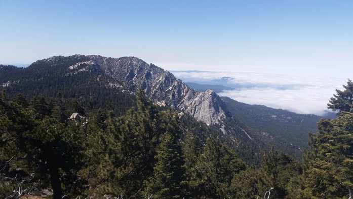

Eventually, the trail began to wind around to the opposite side of the mountain. Our views shifted from the forrest above Idyllwild to the desert of Coachella Valley 8000 ft below. For us, it was quite a unique perspective. During the month of April while working Coachella, we looked at San Jacinto peak longingly not necessarily knowing we would be up on the ridge a month later.
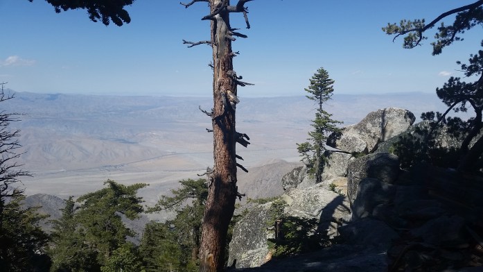
The descent was nearly 20 miles and 8000 ft down to the desert floor below. As we descended, the temperature rose and the massive pine trees that surrounded us earlier were replaced with cacti once more. We cowboy camped for the night about half way down the mountain leaving 14 miles to Interstate 10.

Our morning began at sunrise, and we worked our way down San Jacinto, the summit shrinking as we walked. From this distance, one wouldn’t know about the alpine forrest above despite the incredible size of the trees. The ridges began to collapse upon each other turning a 3D trail into a 2D image. Finally, we hit the desert floor trudging through soft sand that subtracted half a step from each one you took.

We were excited to hit the 10 knowing an In n Out Burger was 7 miles down the interstate, but not thrilled to deal with another fire closure. There are 57 trail miles between the I-10 and Big Bear. Within that stretch, 16 miles of the PCT are actually closed from a devastating wildfire in 2013. Unfortunately, the I-10 and Highway 38 are the only viable roads to get around the closure meaning you skip at least 45 miles of trail if not all 57. (45 if you have control over your ride situation so you can pick up exactly where the fire closure opens on the 38. 57 if you hitch directly to Big Bear and pick up the trail there.)

We’ve heard all sorts of stories about what’s actually going on with this closure. We’ve been told it’s not open from rangers, then heard that some hikers are still passing through. Thankfully, there is a hiker haven right after the I-10 where Ziggy and The Bear host hikers and help you figure out your way to Big Bear in a car, a bus, or on foot if you want to do some road walking.
Before we made it to Ziggy’s, we were spotted on the road by Legend with a truck full of hikers. He quickly offered us a ride to the In and Out and made our trail dreams come true. After lunch and a delightful exchange of conversation with Legend, we returned to Ziggy’s to figure out our ride situation. The shuttle leaving right away was already full so it looked like we would have to wait around to take a short shuttle to a bus that would arrive in Big Bear around 7 pm. That wasn’t our favorite option, but the whole beggars choosers thing. We waited around until an older couple entered offering rides to Big Bear. We jumped on the opportunity with one other hiker, and I couldn’t be happier that we did.

What a very lucky ride we got with Ken and Marcia Powers. Not only are they Triple Crowners (hikers who have completed the AT, PCT, and CDT), they have also hiked thousands more miles including the American Discovery Trail (over 5,000 miles) east to west across the USA and many, many other hiking trails around the country. At a minimum, they have each hiked over 15,000 miles and probably much more than that. They had met all of our hiking heroes and were themselves hiking celebrities. They were on there way to Big Bear on one of their last nights together before Marcia would begin another PCT thru-hike. Check out gottwalk.com (sometime soon, site is under construction!) to see their full story. I was truly dazzled, not only by their accomplishments, but by their kind hearts, generosity, and what they’ve given back to the trails. Maybe one day we’ll come back and hike those 43 miles, but the experience of meeting Ken and Marcia was truly a treat.

We arrived in Big Bear about 5 and were greeted by a familiar face. While working Coachella, I met Alicia, a Vermonter, who currently lives in Big Bear. She warmly invited us to stay in her home when we passed through, and we were happy to take our first zero day after 12 consecutive days of hiking in such a comfortable home. I almost forgot how nice it is to be clean and what clean socks feel like…

Today, we enjoyed food, beers, and the company of an amazing artistic couple that so graciously welcomed us into their home. Tomorrow, we’ll pick the trail back up where the fire closure opens and continue our way north feeling clean, fed, and totally refreshed. Life in motion continues.

Sounds awesome!!!!
❤
Hi guys,
Briefly met you at Crater Lake lodge with my wife and grand daughters. I’ve really enjoyed your travel blog and pictures. Well done!! Safe travels!
Bill & Janet Brawn
Your tales of travel have inspired us to “just do it”. We are heading on a trip Sept 6 to the east coast (Maine) down the east coast to Florida and back on I-10 to Palm Spring in our motorhome “glamping”.
Thank you!! We hope you enjoy your trip and travel safely! Keep following 🙂
Pingback: Every Ounce Counts – The Importance of Ultralight Backpacking – Infinite Geography