
Into the High Sierra at Last

Our arrival at Kennedy Meadows meant the desert was finally behind us leaving 450 miles through King’s Canyon, Sequoia, and Yosemite National Parks, around Lake Tahoe, and finally to Truckee to complete the entire Pacific Crest Trail. I felt a mix of emotions crossing this big milestone, a blend of excitement for the beauty of the High Sierra and anxiety for the still long path ahead. There was much to look forward to yet so much work to be done. Our first chore was leaving Kennedy Meadows near 7,000 ft and climbing to nearly 10,000 ft. Over the next 200 miles, we would stay between 9,000 and 13,000 ft.
From KM we carried just a couple days of food to get us to Lone Pine in our newly purchased bear cans. For the rest of our trip, we would be carrying an extra two and a half lbs of Bear Vault to meet the requirements of the national parks. It took a little strategy, but we eventually figured out how to pack them into our ultralight bags and still maintain a comfortable fit.
Well, mostly anyway. I had already been having a bit of trouble with my bag as I have lost basically all of the extra cushion weight from my body. My pants sagged and my hip belt strap was completely maxed out. The bulk of the can arched in a not so awesome way against my back welcoming new pack rash. Great.
Up we went into the High Sierra, the air becoming slightly thinner and cooler. Sean managed to piss off a bull crossing a high pasture, but thankfully it stopped charging him before we got too scared. Apparently, bulls aren’t into being mooed at by humans.
We are only about 50 miles from KM when it was already time to resupply which requires a little extra work in the High Sierra. For this resupply, we would add an additional 3 miles of walking to get over a pass and down into a valley where there was a drive-in campsite and hope for a ride. Of course, returning to the trail would require redoing those 3 miles in a mostly upward trajectory. Sigh.
Once we reached Horseshoe Meadows Campground, we were pleased to see a full parking lot. It wasn’t too long until a friendly couple offered us a ride down into the town of Lone Pine known for its access to Mt Whitney and stunning scenery frequently used in films.

We immediately made our way to food and quickly talked ourselves into staying in a hotel for the night. We were stoked to check into the historic Dow Motel where we had magnificent views of the High Sierra range including Mt Whitney. We knew we would be at the highest point in the continental US in just two days.

Our time in town flew by, and we left Lone Pine with enough food to get us to Bishop, factoring in the additional miles for Whitney. It took us a little time to find a hitch, but eventually we were back in Horseshoe Meadows Campground preparing to ascend a mountain to get back to the PCT. We managed to knock off a few PCT miles before bed leaving 6 to the ranger station at the base of Whitney.

We arrived at about 10 the morning of Sept 11 to the ranger station. We decided there was no need to carry all of our gear up the mountain so we pitched our tent in the campground and left behind the large majority of our things. It was about 11 when we began the 8 mile, 4,000 ft ascent.
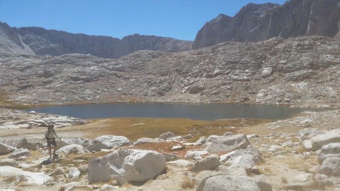
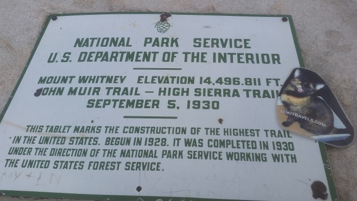
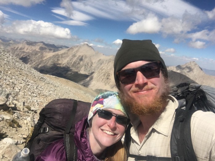
We climbed without seeing too many people as we assumed they had gotten a much earlier start than we did. Up and up we went passing glacial lakes and staring at intricate designs of granite. Whitney’s summit was not in view, but I knew my work was ahead of me as I looked at the surrounding peaks knowing I would be higher than any of the peaks I could see. The higher we climbed, the more mountains came into view many of them over 14,000 ft. We began to notice more and more people as we neared the Whitney Portal, the most common place for hikers to begin and end their summit trip. We were surprised to reach the summit at 2:30, just three and a half hours after we began the climb. By this time, however, several dark clouds darkened the sky leaving little time to enjoy the summit. After a few quick pictures and signing the logbook, we turned back around. We were numbers 80 and 81 to reach the summit that day.

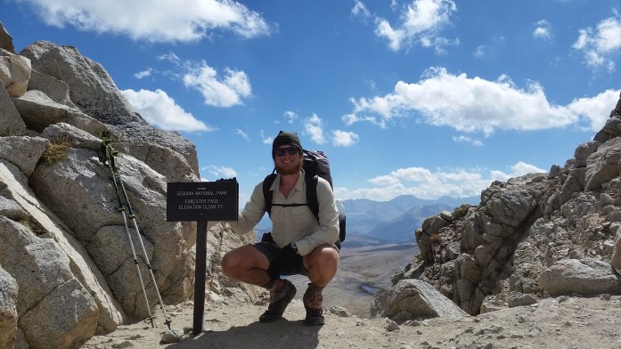
Just as we left the top, the snow began. We were both grateful for snow over rain as we made our way down the mountain. It was nearing 6:00 when we got back to camp, and thankfully the precipitation stopped. Both drained, we went to bed early thinking about the long day ahead of us the next day as we would be climbing Forester Pass, the highest pass on the PCT at 13,200 ft. This would be the first of a series of high altitude passes.
We awoke early, but remained in our tent a little later than usual. Mornings at 10,000+ ft make breaking out of the sleeping bag a little more difficult. Not only had the sun been setting earlier as fall was approaching, the sun was rising later. Summer truly was ending, and those long days were over.
We began our day a little later than usual, still hoping to accomplish a 20+ mile day. From Whitney, trail traffic sharply increased as we were now on the section of the that coincides with the John Muir Trail. It seemed our views only got better and better as we walked, but I resented how little time we took to truly take in our surroundings. The short days, long climbs, and desire to finish walking all added up to not having “extra” time to sit and enjoy.

By midafternoon, we conquered Forester Pass in total awe of the mountains that encompassed us. The clouds began to grow in the sky, and our doubts and fears grew with them. No less than a dozen southbound JMT hikers had warned us of incoming weather for tomorrow or the next day. Temperatures were dropping, and we questioned exactly what we were physically and mentally prepared to deal with. Rain? Freezing rain? Snow?

We began the next day closer to 8:00 which was seemingly becoming our new normal. We were only a couple miles from a trail intersection which would take us 8 miles over Kearsarge Pass and down into Onion Valley Campground. From there, we hoped to hitch our way to Bishop.

Again, it didn’t take too long to find a ride, and just as we were getting into the car, rain started to fall. We were relieved to have dodged the weather bullet. The High Sierra weather report indicated freezing temps and snow above 8,000 ft which made our Bishop hotel room seem that much more cozy.
Sean took the opportunity to buy a new top and bottom base layer at a local outfitter. Our r&r time flew by once more, and we soon found ourselves hitchhiking back to Onion Valley Campground with enough food to get us to Mammoth Lakes.
The thought of 370 more miles weighed on my mind and body. I knew I could do it, but I began asking myself, do I really want to do this anymore? Do I want to walk through this world class trail unhappy, unmotivated, uninspired in order to achieve the arbitrary goal of a complete thru-hike? I did my best to push these thoughts away.
Onward to Mammoth.

Bekah, your resilience is inspiring. I have loved reading not only about your experiences, but also about your mental battles. Thank you for writing, you do it so well. Good luck on your final trek.
Trudie
Thanks, Trudie! Glad you are reading. Hope all is well your way ❤
Good to see you guys on the trail, twice! Into Lone Pine now. The Sierras are wonderful. Get yourselves jobs lined up in Mammoth? Keep in touch.
Pingback: It Wasn’t a Thruhike – Thoughts from Completing the Pacific Crest Trail – Infinite Geography
Pingback: Appalachian Trail vs Pacific Crest Trail – Infinite Geography