
Appalachian Trail vs Pacific Crest Trail

Appalachian Trail vs Pacific Crest Trail
We are frequently asked which trail is “harder” or which trail is “better” both of which are extremely difficult questions to answer. Since these trails traverse entirely different environments, the two trails actually have very little in common other than the fact that they are both long. We completed a northbound thru-hike of the AT in 2015. We completed a “most hike” (2400 miles) of the PCT in 2016 and finished our final 250 miles in 2017. Below, I’ve compared the stats, highlights, and challenges that arise on each trail.

Appalachian Trail (AT) Stats
- Length – 2,190 Miles (3,524.5 km)
- Total Elevation Change – 464,500 ft (141,580 m)
- Average Elevation Change – 212 ft/mile (40 m/km)
- Highest Point – 6,643 ft (2,025 m) – Clingman’s Dome, North Carolina / Tennessee
- Lowest Point – 124 ft (38 m) – Bear Mountain State Park, New York
- Foot Traffic Only
- Completed in 1937
- Southern Terminus – Springer Mountain, Georgia
- Northern Terminus – Mount Katahdin, Maine
- Ave. Northbound Thru-Hike begins March – May and ends August-October
- Ave. Southbound Thru-Hike begins May-July and ends September-November
- Includes 14 States – Georgia, North Carolina, Tennessee, Virginia, West Virginia, Maryland, Pennsylvania, New Jersey, New York, Connecticut, Massachusetts, Vermont, New Hampshire, Maine

Pacific Crest Trail (PCT) Stats
- 2,650 Miles (4,265 km)
- 489,418 ft of Elevation Change (149,174 m)
- 185 Ft/ Mile Average Elevation Change (35 m/km)
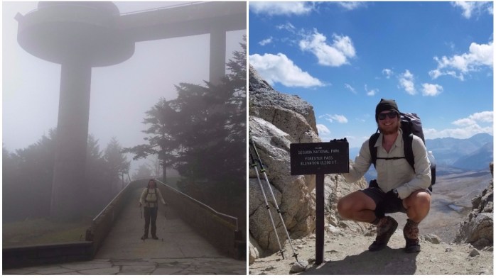
- Highest Point – 13,153 ft (4,009 m) – Forester Pass, California
- Lowest Point – 140 ft (43m) – Cascade Locks, Oregon
- Foot Traffic and Equine Traffic
- Completed in 1993
- Southern Terminus – Mexico / USA border near Campo, California
- Northern Terminus – USA / Canada border near Manning Park, British Colombia
- Ave. Northbound Thru-Hike begins April – May and ends September – October
- Ave. Southbound Thru-Hike begins June – July and ends October – November
- Includes 3 States – California, Oregon, Washington

Highlights of the Trails
Throughout the last few years, I have become passionate for nature and long distance hiking. In my opinion, there is nothing like the freedom of walking in the woods. Although it is not always easy, communing with nature in such a way is truly one of the greatest gifts I have ever received. There is no better way to explore the USA than by way of its epic trails. Here are some highlights I experienced on each trail.
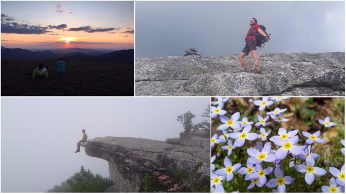
Appalachian Trail
- Watching spring take over the forest first with budding trees and then being surrounded by wildflowers
- Waterfalls
- Ease of navigation, resupply, and general logistics
- Historical sites
- Being surrounded by forest and wildlife – various birds, deer, bears
- Views of green tree covered rolling mountains
- Great community including lots of trail angels and trail magic
- Fall foliage
- Frequent and beautiful water sources
- Rugged trail through moss covered rocks
- Location Favorites: Max Patch, NC; Smokey Mountain National Park, NC / TN; White Mountain National Forest, NH; Maine
Pacific Crest Trail
- Views, views, views
- Changing scenery
- Stunning volcanoes
- High alpine lakes
- Nice weather – barely any rainy days!
- Unique rock and mountain formations
- Specific Locations: Kings Canyon / Sequoia National Parks, CA; Mammoth Lakes, CA; Mt. Shasta, CA; Crater Lake, OR; Mt. Rainier, WA; Glacier Peak Wilderness, WA

Challenges of the Trails

Grade / Steepness
Though the PCT has much higher mountains than the AT, the AT is steeper and more strenuous. The AT tends to summit the mountains in its path while the PCT will meander through the pass between the mountains. The PCT was created to be equine friendly from Mexico to Canada therefore the average grade is considerably less steep than the AT.
Rocks and Roots
The AT is somewhat infamous for its massive boulders and slippery exposed roots. Both obstacles become a major issue and annoyance causing hikers to considerably slow their pace in many sections. Since the PCT is equine friendly, rocks and roots are cleared and rarely create a noticeable problem.

Climate and Weather
AT – The AT has a similar climate from Georgia to Maine and is primarily a forest ecosystem. Thru-hikers starting in February or March may experience temperatures around or below freezing at night in higher altitudes and may see some snow. Summers can bring high heat (~100°F / 38°C) and high humidity. Hikers can expect rain and thunderstorms at anytime. Spring and fall rains can sometimes last for a week or more. You will get wet!
PCT – The PCT differs from the AT in that its sections have a diverse climate and ecosystems ranging from the desert to high altitude above treeline to rain forests. The southernmost section is about 700 miles of desert with scorching highs and cool lows at night. The desert leads into the High Sierra range of California with high altitudes presenting a new challenge. Snow tends to stay in this section until the early summer. Many hikers still need crampons and ice axes when making the traverse in June. Snow returns to the highest points as early as September leaving only a small window for hikers to make it through. Weather in this area is highly unpredictable and can change at any time. Snow melt can make for an easier hike in terms of navigation but can make water crossings extremely dangerous. Snow melt led to the deaths of two thru-hikers that were crossing flooded creeks in 2017 (a very high snow year). Washington is another challenge as the snow lingers for longer in the spring and comes early in the fall. Again, this area is known for unpredictable temperature and weather changes. A 2016 thru-hiker is still missing from a dangerous snow storm in Washington in October of that year. Varying climates and short optimal hiking seasons in some areas are one of the main challenges of this long trail.
In summary, frequent rain is one of the biggest weather related challenges of the AT while environmental extremes contribute to the challenges of the PCT.
Fog, Smog, and Smoke
AT – With the humidity on the East Coast, it’s no surprise that fog is frequent on the AT. Though fog isn’t necessarily a physical challenge, it sure does get annoying when you climb to the top of a mountain only to be socked in with fog. It happened multiple times on our thru-hike, and it’s just one of those things you have to accept and walk on. Thankfully, smog and smoke weren’t an issue at all on the AT in 2015.
PCT – We experienced fog, smog, and smoke on the PCT. Smog was noticeable in Southern California in the desert as we neared Los Angeles, fog affected us in Washington, and smoke was noticeable in Northern California and Washington.

Water
AT – The AT has an abundance of water sources along the trail such as streams, creeks, rivers, and lakes.
PCT – The PCT varies on distance between water sources as the environments change. The desert section of the PCT creates a serious challenge for hikers. There are several 20 mile stretches between sources, and our longest stretch was 42 miles. Though there are some caches, you should never fully rely on them and treat them as emergency sources only. A good rule of thumb is to carry a minimum of 1 L of drinking water for every 4-5 miles you intend to hike. Always treat your water in the back country before drinking. The Pacific Crest Trail Association keeps a crowd sourced water report that is typically very up to date. Check it out here.

Navigation
AT – The AT is clearly marked with white blazes for the majority of the trail. We used AWOL’s AT Guide and did not carry maps. Whatever guide you choose should include distances between shelters and campsites, water sources, roads, and towns.
PCT – The PCT is marked with occasional PCT crests on trees and at trail heads but are not as frequently seen as the AT’s white blazes. We used Guthook’s PCT Guide App as our guide. We did not carry paper maps except as a backup when we were walking through snow covered sections of trail.

Altitude
AT – There are a few times where the AT climbs above treeline such as in the Whites and Smokey Mountains. Because there are somewhat frequent thunderstorms on the AT, it is important to monitor the weather when you are above treeline. Since the AT just barely exceeds 6000 ft, altitude sickness is typically not a problem.
PCT – The PCT spends a lot of time at high altitude and is frequently above treeline. Hikers coming into areas of high elevation from lower ones should take time to acclimate to the new atmosphere. Expect your hike to be somewhat more difficult in high altitudes as your body adjusts to the lessened amount of oxygen.
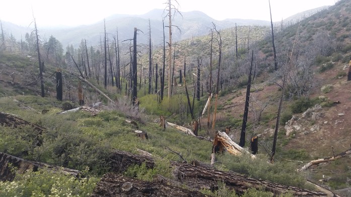
Wildfires
AT – Wildfires do happen on the East Coast and the areas surrounding the Appalachian Trail. Most recently, a large wildfire raged in the Smokey Mountains in 2016 destroying Gatlinburg, TN and thousands of acres of forest. That being said, they are significantly less frequent than on the West Coast. Our AT thru-hike was unaffected by any wildfires.
PCT – Wildfires happen every year on the PCT, can take place in virtually any part of the trail and can cause sections of the trail to be closed for many years after the fire takes place. When planning your PCT trip, you should anticipate the likelihood of active wildfires or closed trail due to past wildfires.
Resupply
AT – The AT crosses many highways that are typically less than 15 miles away from town. We would walk 70-100 miles between resupplies and hitchhike from the trail into town and back. Sometimes, the trail even occasionally walks right through town. We never waited too long for a ride into town and considered the logistics of resupply pretty easy. The entire AT can be done without using resupply boxes. It is easy to resupply at stores and the occasional gas station in town.
PCT – The PCT tends to be further away from towns and longer distances between towns than the AT. Hitchhiking took longer as some highways had very little traffic. Anticipate waiting for a ride longer than you might on the AT. The entire PCT can be done without resupply boxes, but there are a couple of instances where having a box mailed to you makes things a bit easier. For example, the High Sierra section is somewhat of a logistical nightmare for resupply and hikers will have to hike “extra” miles down a side trail to get to a road to get to town.
We used a combination of mail drops and resupplying as we go for both trails. Personally, I don’t recommend mail drops for those people not on a specific diet. To read more about our food resupply strategy for the PCT and how it turned out, click here.
![IMG_20170529_124638_258[1]](https://infinitegeography.com/wp-content/uploads/2017/06/img_20170529_124638_2581.jpg?w=698)
If you’re dehydrating meals then drop boxes are a must! Check out my article explaining how to dehydrate your own meals here.
Bugs, Snakes, and Poisonous Plants
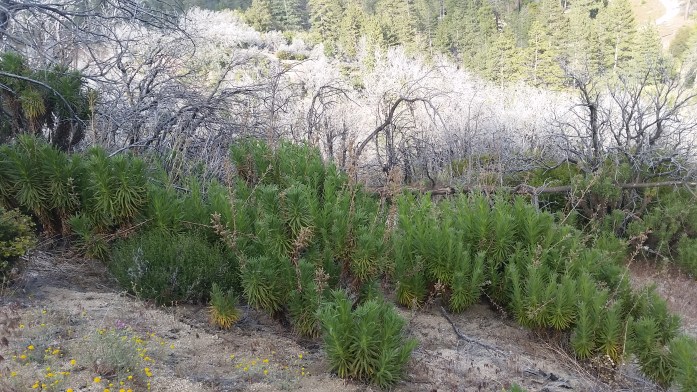
Bugs, snakes, and poisonous plants are a nuisance on both trails. Both trails have mosquitoes and disease carrying ticks, and thru-hikers on both trails can get Lyme disease. Take some time to familiarize yourself to the bugs, snakes, and poisonous plants present in the area. Both trails have their share of poison ivy and poison oak. The PCT additionally has poodle dog bush in the desert that is known to cause burns on people that brush against it.
Mental Challenges
If you’re thinking about a thru-hike, one of the biggest and overlooked challenges of long distance hiking are the mental challenges that come along with it and contributes to whether one might consider the AT or PCT “better” or “harder.” There were times on both trails we were bored, wet, tired, in pain, angry, starving, and with numb minds. Here are some things from each trail that challenged me.
AT – As I’ve mentioned above, the AT is a steep and strenuous hike with constant elevation gain and loss in a similar environment for months on end. Many hikers refer to the AT as the “green tunnel” describing the repetitive scenery. And it rains. A lot. When it’s not raining, the heat and humidity take a toll on your patience. Sprinkle mosquitoes and a Lyme’s Disease diagnosis in there and that’s the AT. Ok, the cynical, less awe inspiring version, but absolutely true. Did I mention there are miles of rocks that come out of nowhere sometimes that will cut your walking speed in half??
PCT – The PCT kept my mind somewhat more occupied with its changing scenery and environments, but not all of those environments are super fun. After a couple hundred miles of desert, carrying 10+ lbs of water through the blazing sun just gets old. Another challenge was the crowds when we started the PCT. As the trails get more popularized, more and more people come out to attempt a thru-hike. For whatever reason, we were largely put off by the crowds and decided to keep to ourselves. However, the large number of people in the beginning eventually led to us turning our planned straight thru-hike into a flip flop.
Though each trail had a few specifics that made them mentally challenging, a lot of the mental challenge was the same between the two trails. Keeping your motivation to finish a long distance trail will always be hard when you are in less than favorable conditions. I would be surprised to meet any hiker that never questioned what in the world they were doing out there. To get a little deeper in my head about the subject, click here to read “How is it out there?” for a more thorough explanation.
Other Differences
Shelters and Camping
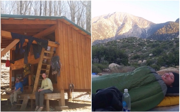
AT– The AT has over 200 shelters open to any hiker. These shelters range from primitive three walled cabins to two story enclosed buildings. Many shelters have picnic tables, a nearby water source, and an area for tent camping. You may stealth camp on the AT at least 200 ft off trail, but this is often times hard to find because of rocks, trees, and uneven ground. You should always carry a tent or hammock and tarp and not rely on finding spot in a shelter.
PCT – The PCT does not have shelters, but I found that tent sites were easy to find and better spread apart than the AT. Since rain is infrequent on the PCT, we were able to “cowboy camp” (ie sleep under the stars without a tent) if it was warm enough.
Gear
AT – We used most of our items throughout our entire thru-hike. We did change our hiking outfit from long sleeves and pants to short sleeves and shorts. Sean switched from a regular sleeping bag to a sleeping bag liner in the summer and then back to the sleeping bag in the fall.
PCT – As the environments of the trail changed, some of our gear changed with it. We carried extra sunscreen and water containers in the desert, extra clothing layers in the High Sierra, and extra rain gear in Washington. The High Sierra and Washington sections may require the use of crampons and ice axes depending on time of year. Also, hikers are required to have a bear can on the PCT through Kings Canyon / Sequoia and Yosemite National Parks.
Click here to check out my gear section for full gear lists and reviews.
Community 
There is a noticeable community that surrounds the AT slightly more than the PCT. This may be because the AT is typically closer to towns than the PCT or because the AT is older. Either way, we experienced more trail magic, trail angels, and caught easier rides on the AT than the PCT.
Summary
So which trail is “better”? Geez, I really couldn’t say. Obviously, it’s a very personal and subjective question. To us, the AT had a more similar environment to the where we grew up in the Midwest, and it felt more like home. On the other hand, the PCT really showed me the best of the West. Both had their challenges, both had their beauty, and I would love to hike them both again.
Have you hiked both the PCT and the AT? Do you have a favorite? Let me know in the comments!
Follow along here or Instagram as we head out for the Continental Divide Trail to complete the Triple Crown in 2018!!
Edit: Since publishing this article, we finished the Continental Divide Trail and our triple crown. Click here to learn more about the CDT!

Thanks for sharing. I just recently started the AT. I hiked Maine and 85 miles in NH this summer and plan to continue next summer to do as much as I can headed south from NH. your article was fun to read and gave great insight!
Thanks for reading! So glad it is helpful 😊
Such a comprehensive answer to this relatively misguided question!!
Thanks! There’s really no short answer to this question!
This was awesome. I haven’t thru hiked either but I would love to one day. I have a little family so we plan on doing the AT in sections. I actually live along the AT in PA so I know the terrain can be challenging!
Thank you! I always say it doesn’t matter how long you’re able to be out there, it’s always worth it!! Doesn’t have to be a thruhike by any means. Good luck to you and your family on the trail!
Pingback: From the Aisle to Counting Miles: Why I’m Thruhiking the Continental Divide Trail
Pingback: 24 Of The Best Books About Walking Obscene Distances Around The World – Red Around the World