
Summer of Summits: Mt Princeton & Mt Antero

This summer we’re attempting to summit as many 14,000+ ft mountains in CO as possible, and we’re reaching the trailheads by bike! Join us on our Summer of Summits.
Day 24 – 19 miles by bike / +2200 ft elevation gain; 13 miles hiking / +5400 ft elevation gain
The day began with a 9 mile bike ride with about 1000 ft of elevation gain to Mt. Princeton trailhead. The lower trailhead has a big parking lot where many people begin the long hike up Mt. Princeton. If you have a high clearance vehicle with 4 wheel drive, you can drive up the mountain quite a ways and safe yourself about half the walk. The road was far too steep and rocky for our touring bikes, so our hike began just past the parking lot.
We had a perfect Colorado Bluebird Sky to begin the day as we walked up the gravel road. From the lot, it’s 6.65 miles each way with 5400 feet of elevation gain to the summit. Considering this was a road, the walk was fairly easy, and we kept a steady pace. Eventually, we came to a trail and exited the road just 2 miles from the summit.
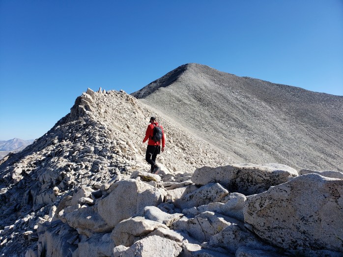
Almost immediately, we rounded a corner where we were finally able to see the summit, the remaining couple miles, and the 2200 ft of climbing ahead. The trail wound through boulder fields and eventually up a series of switchbacks leading to the ridge. We passed a couple small groups of hikers, but overall saw less than a dozen others throughout the whole hike.


During the final ascent, we followed a faint trail through loose rock and dirt, picked over a few more boulders, and made it to the summit about 4 hours after we started.

From the summit, we noted a few peaks we had already climbed and Mount Antero to the south, our next peak. Our time was short spent as our hungry bellies pushed us back to our bikes.


Once we left the ridgeline and boulder fields, it wasn’t long before we were back on the road. With our minds on lunch, we kept a steady jog down the evenly graded road. It took us just about 2.5 hours to return to the bikes and carbo-load.
The day’s work wasn’t quite done. Our next job was riding to the Mt. Antero trailhead 10 miles away with 1200 ft of elevation gain. After a late lunch, we rolled towards our next destination. We passed the Mt Princeton hot springs and continued up a county road passing the Colorado Trail along the way.
At about 6:00 pm, we reached the ATV road that led up Mt. Antero. We did a little searching for a stealth campsite and set an early alarm for the ascent.
Day 25 – 16 miles hiking / +5200 ft elevation gain
Our hike began just before 6:00 am. Mt. Antero boasts the highest trail system in the US for Off Highway Vehicles (OHVs). The road up Mt Antero can be driven up over 13,000 ft and less than a mile from the summit. We saw all sorts of high clearance vehicles, ATVs, and side by sides driving the trail system. If you’re into this type of outdoor recreation, look no further than the Mt Antero trails.

Our climb was an easy one, walking creekside the majority of the time below treeline and enjoying easy switchbacks above treeline. The higher we went, the more magnificent the views of the surrounding mountains became.


Eventually we came to the end of the OHV road and the trail to the summit. The trail basically just followed the ridge until we did a couple of switchbacks through some loose rocks to the top.

The atmosphere at 14,000+ ft isn’t always the most welcoming, but Mt Antero had a pleasant summit this day, and we lingered longer than usual. After thirty minutes of enjoying our 19th summit, we headed back towards the bikes.

We descended the ridge and returned to the road in no time. The walk down was brisk with a few interruptions to let vehicles pass on the narrow road.


At about 1:45, we made it back to the lower trailhead. The 16 miles and 5200 ft of elevation gain took just about 8 hours to complete. Next, we rode a couple of miles to the Colorado Trail walk in campsite. Signs marked the campsite “Closed – no fees / no services” but also included a sign that said “day use and camping ok.” We setup camp stoked for the day ahead.
Day 26 – 27 miles by bike / +200 ft elevation gain, 2700 ft elevation loss 😎
We leisurely woke up and packed the bikes knowing we had an easy day ahead. Salida was just 27 miles away with 2700 ft of elevation loss! We cruised for about an hour and a half into town where town treats and a zero day awaited!!!

If you’re keeping track…
576 Miles by Bike / +48,600 ft elevation gain
146 Miles Hiking / +58,800 ft elevation gain
19 – 14,000+ ft Summits
- Mt Princeton & Mt Antero
- Mt Harvard, Mt Columbia, & Mt Yale
- Mount Sherman
- Mount Massive & Mount Elbert
- Mount of the Holy Cross
- Mt Democrat, Mt Cameron, Mt Lincoln, and (not) Mt Bross
- Quandary Peak
- Torreys and Grays Peaks
- Mount Bierstadt
- Mount Evans
- Long’s Peak
We are Bekah and Sean, out on an adventure to summit as many CO 14ers as possible this summer and reaching them via bicycle! Follow along here or on Instagram as we complete our Summer of Summits.

Pingback: Summer of Summits: Mt. Shavano & Tabeguache Peak – Infinite Geography
Pingback: Summer of Summits: Huron Peak, Missouri Mtn, Mount Oxford & Mount Belford – Infinite Geography
Pingback: Summer of Summits: La Plata Peak – Infinite Geography
Pingback: Summer of Summits: Castle & Conundrum Peaks – Infinite Geography
Pingback: Summer of Summits: Maroon Bells & Pyramid Peak – Infinite Geography
Pingback: Summer of Summits: Snowmass Mountain – Infinite Geography
Pingback: Summer of Summits: Capitol Peak – Infinite Geography
Pingback: Summer of Summits: Carbondale to Denver – Infinite Geography