
Summer of Summits: Mt. Shavano & Tabeguache Peak

This summer we’re attempting to summit as many 14,000+ ft mountains in CO as possible, and we’re reaching the trailheads by bike! Join us on our Summer of Summits.
Day 28 – 14 miles biking / +2700 ft elevation gain
Our time off in Salida evaporated, and it was time to head to our next trailhead. Thankfully, Mt. Shavano and Tabeguache Peak were only 14 miles away from town. We headed due west towards the mountains staying on back roads the entire way. The final six miles were on a gravel road to the trailhead. We were pleasantly surprised that the elevation gain was evenly graded and the whole ride took about 2 and a half hours. Though trail was within the national forest boundary, the surrounding area was on BLM land. We found a dispersed campsite and soon realized we would have company – cows. I blew up my NeoAir sleeping pad which started making a popping noise not long after. The middle of the inflatable pad had become delaminated causing a beach ball effect right in the middle. Thankfully, I had signal and was able to schedule an in-store replacement for the next day in Buena Vista. Not only did the sleeping pad keep me up, the cows were constantly stomping around or snoring which made for a pretty sleepless night.
Day 29 – 10 miles hiking / +5200 ft elevation gain; 31 miles biking / +1000 ft elevation gain
Our day began at about 4:30, and the full moon illuminated the early morning. We started our hike at 5 with a long approach through the forest. The sun was rising just as we got to treeline. Clouds hung in the air and the wind grew as we climbed higher and higher. Just before 8, we approached a saddle with our first summit, Mt Shavano, in sight. The wind whipped from the other side of the ridge and a dark cloud loomed. Suddenly, rain started pelting us as we considered what we should do. Thankfully, a nest built of rocks was nearby, and we ducked for cover.
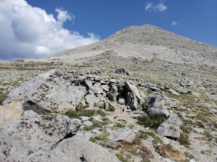
We could see some patches of blue sky, so we decided to time the storm and wait it out. We spent the next 20 minutes grateful for the structure that blocked the wind. The time ticked slowly as we got colder by the passing minute. We considered whether we’d have to turn back and try to summit the following day undoing thousands of feet of climbing. Thankfully, the rain stopped, and the clouds broke. We continued toward the first summit.

From Mount Shavano summit, we could see Tabeguache Peak and the connecting ridge. We took a couple quick pics and started descending.

Once we reached the saddle, our second ascent was about a 400 ft climb. The sun finally came back out from behind the clouds as we approached the summit. We took in the views and could clearly make out the switchbacks of the ATV road climbing Mt Antero behind us.
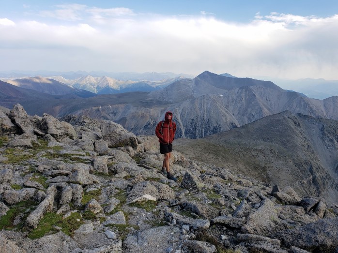


We left Tabeguache Peak and headed back down towards the saddle. Now we got to climb 500 ft back up Mt Shavano to reach the approach trail. At the summit for the second time, we took another pic now that the sky was hazy but mostly cloud free. We were glad to actually have all the climbing done and started our long descent back to camp.


The whole hike took just at 8 hours to complete. We scarfed some lunch, packed up the bikes, and began our 30 mile ride to Buena Vista. First, we wound down the chunky gravel road to the highway. Next, we spent about two hours rolling up and down hills as we passed view points of several mountains we had already summited. We were ecstatic to reach Buena Vista (and my new sleeping pad!) after a very long day.
If you’re keeping track…
621 Miles by Bike / +52,300 ft elevation gain
156 Miles Hiking / +64,000 ft elevation gain
21 – 14,000+ ft Summits
- Mt Shavano & Tabeguache Peak
- Mt Princeton & Mt Antero
- Mt Harvard, Mt Columbia, & Mt Yale
- Mount Sherman
- Mount Massive & Mount Elbert
- Mount of the Holy Cross
- Mt Democrat, Mt Cameron, Mt Lincoln, and (not) Mt Bross
- Quandary Peak
- Torreys and Grays Peaks
- Mount Bierstadt
- Mount Evans
- Long’s Peak
We are Bekah and Sean, out on an adventure to summit as many CO 14ers as possible this summer and reaching them via bicycle! Follow along here or on Instagram as we complete our Summer of Summits.

Pingback: Summer of Summits: Huron Peak, Missouri Mtn, Mount Oxford & Mount Belford – Infinite Geography
Pingback: Summer of Summits: La Plata Peak – Infinite Geography
Pingback: Summer of Summits: Castle & Conundrum Peaks – Infinite Geography
Pingback: Summer of Summits: Maroon Bells & Pyramid Peak – Infinite Geography
Pingback: Summer of Summits: Snowmass Mountain – Infinite Geography
Pingback: Summer of Summits: Capitol Peak – Infinite Geography
Pingback: Summer of Summits: Carbondale to Denver – Infinite Geography